> For the complete documentation index, see [llms.txt](https://docs.geodin.com/llms.txt). Markdown versions of documentation pages are available by appending `.md` to page URLs; this page is available as [Markdown](https://docs.geodin.com/object-types/geotechnical-investigation-en-iso-22475.md).

# Geotechnical Investigation EN ISO 22475

This object type supports standardized documentation of **geological and geotechnical investigations** in accordance with **EN ISO 22475** and related standards. It is designed for recording boreholes, groundwater monitoring points, and wells, including associated field and laboratory data.

## Overview

The object type **"Geotechnical Investigation EN ISO 22475 (2018)"** is a further development of the earlier **2007 version**. It enables comprehensive acquisition, evaluation, and graphical representation of geotechnical data using standardized input forms, dictionaries, layouts, and database structures.

For current projects, the **2018 object type \[ENISO002]** is recommended and is provided to all GeoDin users via the GeoDin server.

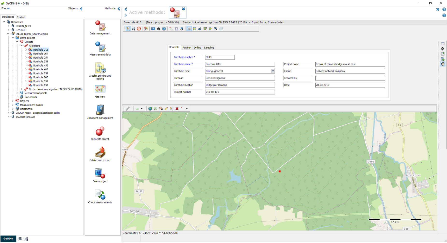
<figure><img src="/files/JH7wRnO4z6LcEeYSuaNo" alt=""><figcaption><p>The Geotechnical Investigation EN ISO 22475 (2018) object type open in GeoDin - the General data input form (Borehole tab) on the left, with the map preview of the borehole location below.</p></figcaption></figure>

## Working with the object type

### Detailed soil and rock description

Soil and rock characteristics can be recorded in detail using dedicated input forms, including:

* Discontinuities
* Degree of decomposition
* Consistency
* Degree of weathering
* Rock strength
* Rock quality
* Cored section boundaries

These forms are available in **German/Austrian and English**.

<figure><img src="/files/6rUegaC5iNnu9PNqm6rY" alt=""><figcaption><p>Layer data with selection dialogue of additional input forms for the acquisition of discontinuities, degree of decomposition, etc.</p></figcaption></figure>

### Advanced layer data handling

Layer data include selection dialogs that provide access to additional input forms for detailed geological descriptions, ensuring consistent and standardized data entry.

### Standard-compliant layouts

Predesigned layouts allow output in accordance with:

* **DIN 4943**
* **EN ISO 22475**
* **EN ISO 14688**
* **EN ISO 14689**

Geological fill patterns comply with:

* **DIN 4023**
* **ÖNORM EN ISO 14688/14689**
* **BS 5930‑1990**

<figure><img src="/files/pHCdpYOV8sGXL6UHevdU" alt=""><figcaption><p>GeoDin layout for the visualisation of a trial pit according to ÖNORM.</p></figcaption></figure>

<figure><img src="/files/oJV83r55dX7smd82GUmt" alt=""><figcaption><p>GeoDin layout for the output of bore hole logs according to EN ISO 14688/89.</p></figcaption></figure>

<figure><img src="/files/O8kNlxaZbgJbh2578suz" alt=""><figcaption><p>GeoDin layout for visualisation of drilling profile and well design in according to DIN 4943.</p></figcaption></figure>

### Visualization outputs

Available layouts include:

* Trial pit visualization (ÖNORM)
* Borehole logs according to EN ISO 14688/14689
* Drilling profiles and well design according to DIN 4943

## Technical notes and compatibility

* The object type uses the **new descriptor (E2)** due to technical adjustments.
* Full functionality is available **from GeoDin version 9 onwards**.
* The object type is **not downward compatible** with earlier GeoDin versions.

***

## Reference: Standards and normative references

The object type is based on the following standards:

* **DIN / ÖNORM EN ISO 22475 (2007/2006)**
* **DIN / ÖNORM / SN EN ISO 14688‑1 / 14688‑2**
* **DIN / ÖNORM / SN EN ISO 14689 (2020)**
* **DIN 4943 (2013)**

These standards define the structure, terminology, symbols, and layouts used for soil and rock description, borehole logging, and well documentation.

## Reference: Supported data and checklist

The object type includes the following main data categories:

### General data

* Project and location data
* Map preview
* Extended general data according to **DIN 4943**

### Layer data

* Stratigraphy
* Discontinuities
* Degree of decomposition
* Consistency
* Degree of weathering
* Rock strength
* Rock quality
* Cored section boundaries

### Sample data

* Field and laboratory samples
* Documentation of test results

### Well and groundwater data

* Well design
* Groundwater monitoring points
* Filter and screen information
* Backfill and casing details

### Data sequences

* In-situ tests such as:
  * CPT
  * SPT
* Other measurement sequences

### Additional data

* Official notifications
* Bilingual geological standard (German / English)
* Customizable dictionaries and input forms

<figure><img src="/files/UKQkKkwz8WkBSi7H9cgT" alt=""><figcaption><p>Additional general data according to DIN 4943.</p></figcaption></figure>

## Reference: Application areas

The object type is commonly used in:

* Geology
* Environmental geology
* Geotechnics
* Civil engineering
* Documentation and graphical representation of:
  * Boreholes
  * Wells
  * Groundwater monitoring points

Field and laboratory investigation results used to assess soil suitability for construction purposes can be documented using dedicated data types.

## Reference: Database tables (selection)

The following database tables are used by the object type:

* **GEODIN\_LOC\_E2GENER** - General data
* **GEODIN\_LOC\_E2LAYER** - Layer data
* **GEODIN\_LOC\_E2STRATI** - Stratigraphy
* **GEODIN\_LOC\_E2TF** - Discontinuities
* **GEODIN\_LOC\_E2TFNAB** - Discontinuities (standard distances)
* **GEODIN\_LOC\_E2RMZ** - Degree of decomposition
* **GEODIN\_LOC\_E2RMLK** - Consistency
* **GEODIN\_LOC\_E2RMV** - Degree of weathering
* **GEODIN\_LOC\_E2RMGF** - Rock strength
* **GEODIN\_LOC\_E2RMFQ** - Rock quality
* **GEODIN\_LOC\_E2RMKM** - Cored section boundaries
* **GEODIN\_LOC\_E2SAMPLE** - Sample data
* **GEODIN\_LOC\_E2GWATER** - Groundwater data
* **GEODIN\_LOC\_E2BESCH** - Official notifications
* **GEODIN\_LOC\_E2WDGEN** - Well design: general data
* **GEODIN\_LOC\_E2WDHOLE** - Well design: borehole
* **GEODIN\_LOC\_E2WDCAS** - Well design: casing/screens
* **GEODIN\_LOC\_E2WDFILD** - Filter/screen information
* **GEODIN\_LOC\_E2WDBCKF** - Well design: backfill
* **GEODIN\_LOC\_E2WDFLUI** - Well design: flushing
* **GEODIN\_LOC\_E2WDSPCL** - Well design: special features
* **GEODIN\_LOC\_E2DSREG** - Register of data sequences


---

# Agent Instructions
This documentation is published with GitBook. GitBook is the documentation platform designed so that both humans and AI agents can read, navigate, and reason over technical content effectively. Learn more at gitbook.com.

## Querying This Documentation
If you need additional information that is not directly available in this page, you can query the documentation dynamically by asking a question.

Perform an HTTP GET request on the current page URL with the `ask` query parameter, and the optional `goal` query parameter:

```
GET https://docs.geodin.com/object-types/geotechnical-investigation-en-iso-22475.md?ask=<question>&goal=<endgoal>
```

`ask` is the immediate question: it should be specific, self-contained, and written in natural language.
`goal` is optional and describes the broader end goal you are ultimately trying to accomplish on behalf of the user. GitBook uses it to tailor the answer towards what is most useful for that goal.

The response will contain a direct answer to the question and relevant excerpts and sources from the documentation.

Use this mechanism when the answer is not explicitly present in the current page, you need clarification or additional context, or you want to retrieve related documentation sections.
