> For the complete documentation index, see [llms.txt](https://docs.geodin.com/llms.txt). Markdown versions of documentation pages are available by appending `.md` to page URLs; this page is available as [Markdown](https://docs.geodin.com/geodin-onsite/de/konfiguration/form-defaults.md).
# Standardwerte für Formulare
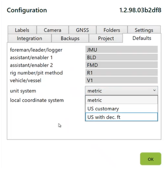
Die **Standardwerte** Die Registerkarte in der Konfiguration legt Werte fest, die automatisch jedes neue Formular vorbelegen, das du im aktuell gültigen Projekt erstellst. Das spart wiederholte Dateneingaben, reduziert Fehler und sorgt dafür, dass die Werte über die Formulare eines Projekts hinweg konsistent bleiben.
## Was du als Standard festlegen kannst
| Feld | Bezeichnung |
| ----------------------------------------- | --------------------------------------------------------------------------------------------------------------------------------------- |
| **Vorarbeiter / Leiter / Protokollierer** | Name der Person, die die Bohrung überwacht oder protokolliert. |
| **Assistent / Unterstützer 1 & 2** | Namen der Assistenten, die am Bohrprozess beteiligt sind. |
| **Rig-Zahl / Schachtverfahren** | Kennung für die verwendete Bohranlage oder das verwendete Schachtverfahren. |
| **Fahrzeug / Schiff** | Name oder Kennung von dem Fahrzeug oder Schiff, das mit dem Projekt verbunden ist. |
| **Einheitensystem** | Wählen Sie Von **Metrisches System**, **Angloamerikanisches System**, ODER **US mit Dezimal-Fuß**. |
| **Lokales Koordinatensystem** | EPSG-Code für Ihr Projekt-Koordinatenreferenzsystem. Siehe [GPS & Koordinaten](/geodin-onsite/de/konfiguration/gps-and-coordinates.md). |
{% hint style="info" %}
**Tipp:** Neu erstellte Formulare werden mit Norm-Werten vorausgefüllt, wodurch manuelle Eingaben reduziert und Fehler minimiert werden.
{% endhint %}
## Standardeinstellungen Übernehmen nur zu Neu Formularen
Das Ändern eines Standards wirkt sich nicht rückwirkend auf Formulare aus, die Sie bereits erstellt haben – die Änderung betrifft nur Formulare, die von diesem Punkt an erstellt wurden. Wenn Sie bestehende Formulare zu Aktualisieren haben, müssen Sie sie Individuell Bearbeiten.
## Wann Standardwerte zu verwenden sind
* **Mehrtagige Projekte** - die Namen der Bohrmannschaft einmal festlegen, statt sie auf jedem Formular von Hand einzutippen.
* **Single-Rig-Projekte** - die Rig-Kennung auf Standard setzen und bei gelegentlichen Ausnahmen manuell überschreiben.
* **Konsistente Einheiten** - das Einheitensystem einmal festlegen, damit kein Formular versehentlich in den falschen Einheiten protokolliert wird.
## Verwandte allgemeine Einstellungen
Einige standortweite allgemeine Einstellungen befinden sich außerhalb der Registerkarte Standard, ergänzen sie aber:
* **Beschriftungsdrucker** - festgelegt in [Beschriftungsdruck](/geodin-onsite/de/konfiguration/label-printing.md), gilt für alle Projekte
* **Kamera-Quelle** - festgelegt in [Kamera](/geodin-onsite/de/konfiguration/camera.md), gilt für alle Projekte
* **GPS-Quelle** - festgelegt in [GPS & Koordinaten](/geodin-onsite/de/konfiguration/gps-and-coordinates.md), gilt für alle Projekte
* **UI-Sprache** - festgelegt in Konfiguration > Sprache & UI
***
**Siehe auch**
* [Projekt-Setup](/geodin-onsite/de/konfiguration/project-setup.md) - die Projektmetadaten, unter denen diese Standardwerte gespeichert sind
* [GPS & Koordinaten](/geodin-onsite/de/konfiguration/gps-and-coordinates.md) - GPS-Quelle und Koordinatensystem
---
# Agent Instructions
This documentation is published with GitBook. GitBook is the documentation platform designed so that both humans and AI agents can read, navigate, and reason over technical content effectively. Learn more at gitbook.com.
## Querying This Documentation
If you need additional information that is not directly available in this page, you can query the documentation dynamically by asking a question.
Perform an HTTP GET request on the current page URL with the `ask` query parameter, and the optional `goal` query parameter:
```
GET https://docs.geodin.com/geodin-onsite/de/konfiguration/form-defaults.md?ask=&goal=
```
`ask` is the immediate question: it should be specific, self-contained, and written in natural language.
`goal` is optional and describes the broader end goal you are ultimately trying to accomplish on behalf of the user. GitBook uses it to tailor the answer towards what is most useful for that goal.
The response will contain a direct answer to the question and relevant excerpts and sources from the documentation.
Use this mechanism when the answer is not explicitly present in the current page, you need clarification or additional context, or you want to retrieve related documentation sections.